What it actually takes
What is the difference between flying a drone as recreational activity and providing professional commercial drone service and why it not the same.
Here we give a real life example of a typical aerial mapping job in the developing country like Fiji.
THE OBJECTIVE
To produce survey grade map of an area approximately 35 acres with an extended margin of around 50 to 100m around the area of interest. Make the client happy by providing all the geospatial data they need. Get paid.
The client: A respected development consulting firm from Suva
To legally execute commercial drone operation in Fiji and deliver quality results with required accuracy it will take quite a few steps before you even start the propellers.
It involves obtaining relevant permits and authorisation from CAAF (Civil Aviation Authority of Fiji), equipment suitable for the job, mission planning, processing software and hardware.
List of equipment and other things we need
- GNSS base station receiver for surveying of the base reference point if CORS data is not available for the area (for most of the Fiji Islands there is none for public use)
- An UAV (Unmanned Aerial Vehicle or just drone) capable of performing safe programmed flight, equipped with certain quality RGB sensor and GNSS receiver to achieve centimetre level mapping accuracy.
- Transportation. Usually 4x4 vehicle as Fiji road system is what it is.
- Licensed software that processes PPK and RTK data and able to do Precise Point Position calculations on GNSS logs since no CORS data available
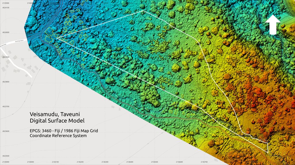
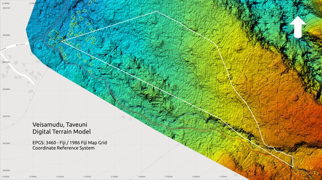
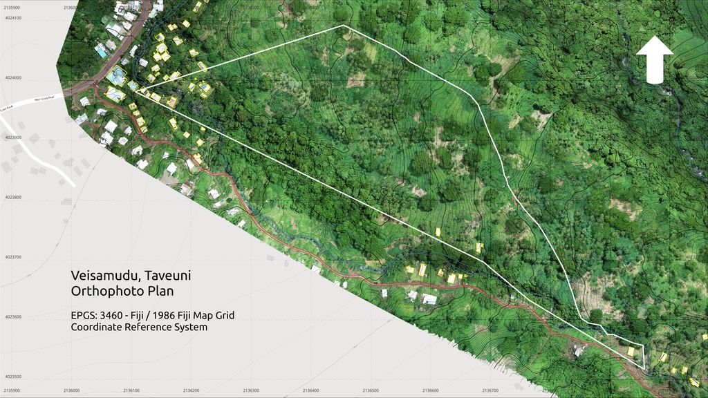
- Software for processing geo-tagged images in order to have orthophoto rasters, digital surface and terrain models
- Enough computing power. 16 core CPU with 128 GB of RAM machine
- GIS software for post processing terrain data, elevation contour lines and delivering printable mapping materials
- Enough drone batteries (they are quite expensive themselves around $500 FJD each)
- A drone pilot. Usually a person that knows what they are doing with relevant experience and skills. For particular large areas where not possible to have direct line of sight there also should be an extra person - the observer.
Legal stuff
- The drone pilot must have certification relevant to the class of the drone they fly. The certificate must be recognised by the local Civil Aviation Authority. In Fiji it is CAAF
- The RPAS operator (drone operator) that commences commercial drone operations in Fiji must have a valid insurance with $1M FJD coverage.
- The drone operator must also hold a valid CAAF permit in order to operate above 200ft altitude and within airport authorization and no-fly zones.
- If the area of operations actually located withing airport authorization or no-fly zones when CAAF permit granted, we also have to apply for NOTAM in order to operate in the area.
Stage 1: Reconnaissance
1 to 5 days depends on the project size and complexity
There is no professional drone job to be done without prior reconnaissance and area study and analysis. Period.
First we study the area in the office. The client provides us some initial details regarding their property.
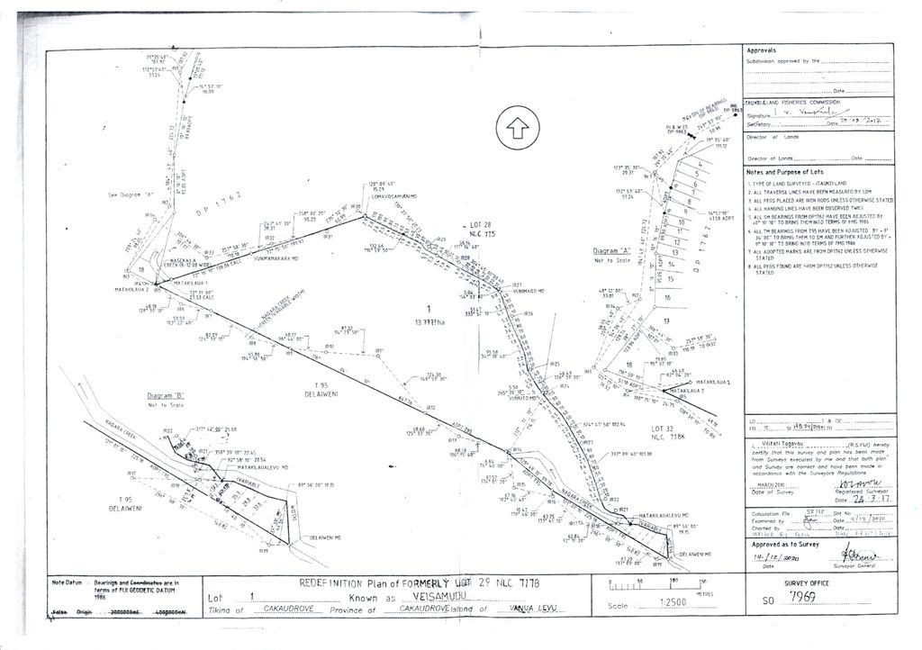
If there is a parcel of land, we need to know its precise boundaries and study the area within and around it. We must get ourselves familiar with all of that before taking the flight.
In case of a freehold land title the land's title details would be sufficient to locate the land and trace it's boundaries coordinates from Vanua GIS.
To have the list of land boundary coordinates is ideal but usually it is not available so we will have to extract the boundary data ourselves from different sources available. Like this the only piece of paper we could get.
Once we have the boundaries coordinates and know the land parcel precise location, we study the area in and out. Analysing the terrain, the neighbouring properties, access roads and possible operation locations.
Then we take a trip to the location to see it ourselves and find a spot from where to operate.
We must ensure that we have 100% direct line of sight to supposed drone location in the sky for the entire area of operation. If we don't find suitable location where we were expected to have it, we spend some time looking for it. We might find it or might have to come again.
It might be easy and might be not at all. The ideal scenario is when we just drive all the way right to the operation spot and there is shade, picnic table and cold drinks (we such wonderful location in Taveuni), but in most cases we will likely have an exhausting hike, sometimes couple of hours long walk up the hill from where we can observe the sky above the tree canopy properly then we mark that position.
Surveying the base station reference point
To achieve the survey grade accuracy that can be certified by licensed surveyor we employ various tools and approaches. PPK or (Post Process Kinematics) is one of them and PPP (Precise Point Positioning) is another. In order to get precise coordinates for our GNSS base (known location) we must record GNSS base logs for at least 4 hours at the location not further than 8 km from the operation area, ideally it should be in the operation area itself. To have precise know location coordinates for our base we must record 4+ hours of GNSS base logs. Some times we can leave the base and go for lunch to come back late, but often we must stay nearby and just wait for 4 hours straight. Boring stuff. Then we bring the GNSS logs to the office and process in special software using NASA ephemeris files to get the most accurate possible static geographic coordinates for our base reference point. Those coordinates will be used in further images PPK processing after we collect all the data during the drone flying stage.
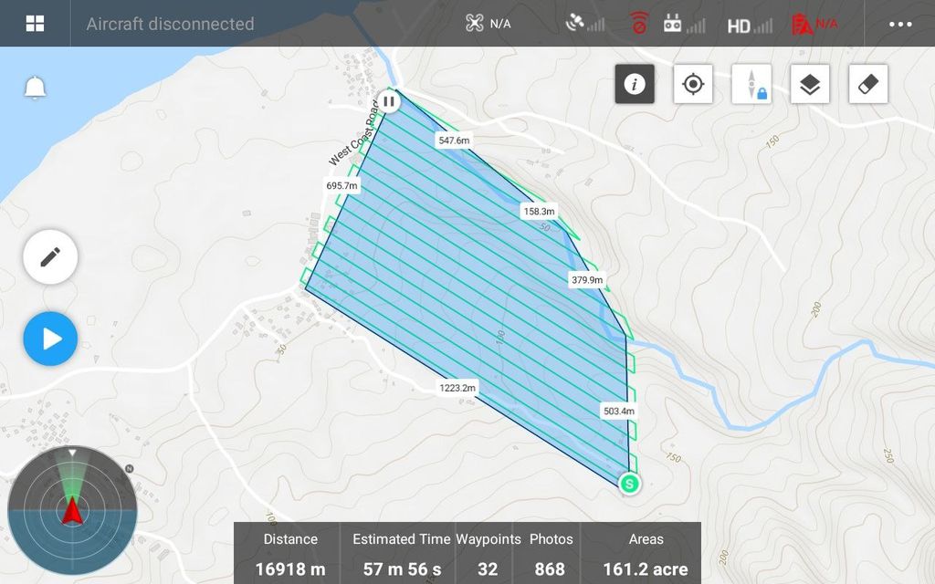
Mission planning
Once we collect all the area data we program drone autopilot using specialised software. While planning the mission we must consider terrain, wind forecast and direction, chance of precipitation, distances from flight operation site and possible complications, time and other factors.
Then we plot and calculate the flight courses, angles, altitudes, batteries estimates and load it all in flight controller.
We also create pre-flight checklists. They are same important as real plane checklists. They help not to forget important things. In some case scenarios forgetting something important might not cost someone's life but time and money. A lot of it. So we always make sure it doesn't.
Stage 2: The drone time also called "The field work"
Up to 4 hours a day for required number of days depending on project size and complexity
Small projects (up to 80 acres) normally take up to 1-2 hours of field work
Here we finally come to perform actual flight. It is the only activity the client might understand more or less as it is visible. Drone flying takes the shortest amount of time (if well planned) compared to any other stages of the job, but it is practical skills and concentration demanding. One little thing forgotten and you will have to redo it all again or will not be able to complete in the planned time frame.
We arrive at the operation location around planned time, prepare the equipment, check the weather forecast, inform CAAF about the activity (if required) go through pre-flight checklist, load flight mission data in the drone and execute.
Stage 3: Processing raw geospatial data results and map rasters
1 - 2 days depending on project complexity and size
If we were lucky and collected all the data properly. We PPK process the images by loading them in special software, then in another software and another. There is a cascade of processing stages. For particularly large datasets we hire computing power in the cloud where processing might take up to 24 hours, but usually it is complete withing 3-6 hours for the datasets of an average size.
Stage 4: Post processing and geospatial digitising
1 - 2 days depending on project complexity and size
Once datasets processed and we have maps and digital models raster files ready. We load them in GIS software where further processing takes place and where we process elevation contour lines, various models and printable mapping materials to share with the client and stakeholders. It includes data for GIS, Autocad and other applications that client might need it for.
It is not cheap but the way we do it makes it affordable and the data you get might save true fortune compared to when we don't have such data. Simply because the decisions that you make about your "million dollar property" or "multi million dollar development project" to be well informed decisions, based on objective geospatial and terrain data.