Digitizing old paper maps and survey plans
We take last century old, stale smelling, hard to read and understand maps and survey plans and turning them into modern, vibrant, useful data driven digital assets that can be further used in various software for planning and viewed online.
Fiji is notorious with it's Fiji time, old inaccurate maps and land disputes.
Resolving such problems in traditional way remains quite an expensive adventure, especially for land owners in remote and maritime areas. And so, many landowners choose to just "leave it like that" for generations as they don't see any feasible cost efficient way of fixing the inconsistencies.
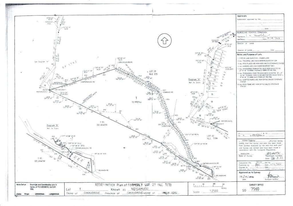
Many potential and new land owners, especially overseas based, when expressed their interest or purchased the land usually left with a title and old survey plans like the one bellow to guess what to do with it.
Yes they understand the value of their property, the boundaries, it's area size but what else? And the the questions come.
- Where exactly on the world map it located?
- What is around?
- What is terrain like?
- Are there any complications?
- Are there any squatters currently present on the property or neighbours encroaching?
- How I'd develop it?
- Where would I build the house?
- How would I place it towards the ocean, mountains, forest and other landscape features so there would be best possible views?
- Where to make a garden or what part of land set for farming?
- And so on and so on
Our geospatial digitizing service provides invaluable information so the land owners be able to make informed decisions
What we can do with your old paper map or survey plan
We accurately trace the boundaries and geo-reference them according to actual local and world coordinates. As a result you get your boundaries digitized and be able to work with them in digital format using Autocad, GIS or easy to use free planning and subdividing tools that we specially developed for your convenience.
And instead of this
You have something like this
Geospatial digitizing of parcel of a native land on the island of Taveuni, Fiji
Real life project results of "Full package" geospatial digitizing of old survey plan. It includes orthophoto map, elevation contour lines with 1m interval, digital terrain and surface models produced with tracing of rivers, creeks, roads, buildings and other man made objects withing the land boundaries and around. Autocad DXF and other vector data files.
This map was created in MapHub. You can open it in a separate window for detailed and more comfortable viewing.
Savasi Island
Savasi Island. Real life geospatial digitising project from 2023. It includes digitizing of paper maps and surveyor plans, mapping and contours tracing.
This map was created in MapHub. You can open it in a separate window for detailed and more comfortable viewing.
Waruka Bay Qamea
Total restoration of land boundaries and mapping the beach area.
This map was created in MapHub. You can open it in a separate window for detailed and more comfortable viewing.
A set of 5 freehold lots in Taveuni
The project was complete in February 2024 for overseas client that received invaluable scalable map of the land and everything on it in high resolution photographic quality with digitized boundaries precisely laid over plus elevation profiles and terrain models for development planning. And it all started from badly scanned old surveyor paper plan and title details.
This map was created in MapHub. You can open it in a separate window for detailed and more comfortable viewing.
So. Where do we start?
Simply contact us and send us a scan of your land survey paper plan and title details (land parcel number). Also the type of land. Native lease, freehold etc. We will get back to you with quote or additional questions shortly.
Important Note
The geospatial data results we produce are survey grade correct, but have no legal power and intended for personal use only.
If you need to use such data for legal or engineering purpose it will have to be verified and certified by a licensed surveyor. We can assist with that.